


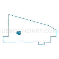
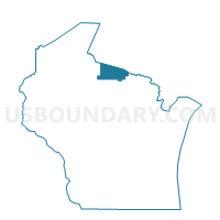
ARBOR VITAE - T 4 Voting District, Vilas County, Wisconsin
About
Outline

Summary
| Unique Area Identifier | 697384 |
| Name | ARBOR VITAE - T 4 Voting District |
| County | Vilas County |
| State | Wisconsin |
| Area (square miles) | 11.48 |
| Land Area (square miles) | 9.10 |
| Water Area (square miles) | 2.38 |
| % of Land Area | 79.27 |
| % of Water Area | 20.73 |
| Latitude of the Internal Point | 46.02963660 |
| Longtitude of the Internal Point | -89.71071300 |
Maps

Graphs
Select a template below for downloading or customizing gragh for ARBOR VITAE - T 4 Voting District, Vilas County, Wisconsin


Neighbors
Neighoring Voting District (by Name) Neighboring Voting District on the Map
- ARBOR VITAE - T 1 Voting District, Vilas County, WI
- BOULDER JUNCTION - T 1 Voting District, Vilas County, WI
- BOULDER JUNCTION - T 2 Voting District, Vilas County, WI
- LAC DU FLAMBEAU - T 1 Voting District, Vilas County, WI
Top 10 Neighboring County Subdivision (by Population) Neighboring County Subdivision on the Map
- Lac du Flambeau town, Vilas County, WI (3,441)
- Arbor Vitae town, Vilas County, WI (3,316)
- Boulder Junction town, Vilas County, WI (933)
Top 10 Neighboring Elementary School District (by Population) Neighboring Elementary School District on the Map
- Woodruff Joint No. 1 School District, WI (5,371)
- Lac du Flambeau No. 1 School District, WI (3,438)
- North Lakeland School District, WI (2,513)